
Haz una donación
Equípate para tu próxima aventura:
Como asociado de Amazon, este sitio gana comisiones por las compras que califican, sin ningún costo adicional para usted.
Mapa topográfico Hill Top
Haga clic en el mapa para ver la altitud.
Haz una donación
Equípate para tu próxima aventura:
Como asociado de Amazon, este sitio gana comisiones por las compras que califican, sin ningún costo adicional para usted.
Acerca de este mapa
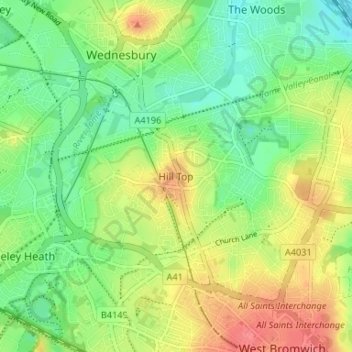
Nombre: Mapa topográfico Hill Top, altitud, relieve.
Altitud media: 138 m
Altitud mínima: 111 m
Altitud máxima: 174 m
Haz una donación
Equípate para tu próxima aventura:
Como asociado de Amazon, este sitio gana comisiones por las compras que califican, sin ningún costo adicional para usted.
Otros mapas topográficos
Haga clic en un mapa para ver su topografía, su altitud y su relieve.
Rowley Hills
United Kingdom > England > Sandwell > Tividale
The largest hill, Turner's Hill, is the highest point in the West Midlands county, with an altitude of 269 metres (883 ft) above sea level. Views from the summit include the Clee Hills, Clent Hills, Cannock Chase, and much of Birmingham and the Black Country. The height has also led to the construction of two…
Altitud media: 182 m
Causeway Green Park
United Kingdom > England > Sandwell > Causeway Green > The Ashes
Altitud media: 184 m