Geolocalizar

Mapa topográfico Oberiberg

Mapa interactivo

Haga clic en el mapa para ver la altitud.

Acerca de este mapa

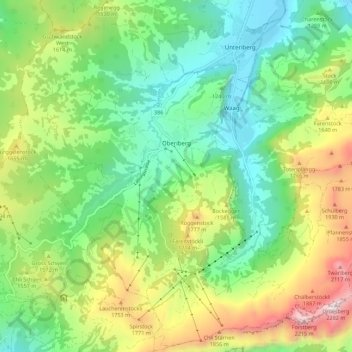
Nombre: Mapa topográfico Oberiberg, altitud, relieve.

Lugar: Oberiberg, Schwyz, 8843, Schweiz (46.99447 8.73294 47.06960 8.84390)

Altitud media: 1.369 m

Altitud mínima: 901 m

Altitud máxima: 2.269 m

Otros mapas topográficos

Haga clic en un mapa para ver su topografía, su altitud y su relieve.

Arth

Schweiz > Schwyz > Schwyz

Arth, Schwyz, Schweiz

Altitud media: 865 m

Glattalp

Schweiz > Schwyz > Schwyz > Muotathal

Glattalp, Muotathal, Schwyz, 6436, Schweiz

Altitud media: 1.937 m

Unterschönenbuch

Schweiz > Schwyz > Schwyz > Ingenbohl

Unterschönenbuch, Ingenbohl, Schwyz, 6438, Schweiz

Altitud media: 615 m

Muotathal

Schweiz > Schwyz > Schwyz

Muotathal, Schwyz, 6436, Schweiz

Altitud media: 1.439 m

Brunnen

Schweiz > Schwyz > Schwyz > Brunnen

Brunnen, Ingenbohl, Schwyz, 6440, Schweiz

Altitud media: 592 m

Morschach

Schweiz > Schwyz > Schwyz

Morschach, Schwyz, Schweiz

Altitud media: 797 m

Hüseren

Schweiz > Schwyz > Schwyz > Riemenstalden

Hüseren, Riemenstalden, Schwyz, 6452, Schweiz

Altitud media: 1.334 m

Sattel

Schweiz > Schwyz > Schwyz

Sattel, Schwyz, 6417, Schweiz

Altitud media: 989 m

Steinen

Schweiz > Schwyz > Schwyz

Steinen, Schwyz, 6422, Schweiz

Altitud media: 675 m

Rigi

Schweiz > Schwyz > Schwyz > Arth

Rigi, Arth, Schwyz, 6356, Schweiz

Altitud media: 1.265 m