
Mapa topográfico Unkel
Mapa interactivo
Haga clic en el mapa para ver la altitud.
Acerca de este mapa
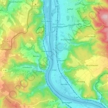
Nombre: Mapa topográfico Unkel, altitud, relieve.
Lugar: Unkel, Landkreis Neuwied, Rhineland-Palatinate, Germany (50.58362 7.21001 50.63549 7.31667)
Altitud media: 147 m
Altitud mínima: 50 m
Altitud máxima: 330 m
Otros mapas topográficos
Haga clic en un mapa para ver su topografía, su altitud y su relieve.
Sankt Katharinen
Germany > Rhineland-Palatinate > Landkreis Neuwied > Sankt Katharinen
Sankt Katharinen, Linz am Rhein, Landkreis Neuwied, Rhineland-Palatinate, 53562, Germany
Altitud media: 299 m
Windhagen
Germany > Rhineland-Palatinate > Landkreis Neuwied > Windhagen
Windhagen, Asbach, Landkreis Neuwied, Rhineland-Palatinate, 53578, Germany
Altitud media: 266 m