
Mapa topográfico Dornum
Mapa interactivo
Haga clic en el mapa para ver la altitud.
Acerca de este mapa
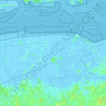
Nombre: Mapa topográfico Dornum, altitud, relieve.
Lugar: Dornum, Landkreis Aurich, Lower Saxony, 26553, Germany (53.61923 7.31399 53.69312 7.55813)
Altitud media: 1 m
Altitud mínima: -4 m
Altitud máxima: 9 m
Otros mapas topográficos
Haga clic en un mapa para ver su topografía, su altitud y su relieve.
Wiegboldsbur
Germany > Lower Saxony > Landkreis Aurich > Wiegboldsbur
Wiegboldsbur, Südbrookmerland, Landkreis Aurich, Lower Saxony, Germany
Altitud media: 0 m
Wiesmoor
Germany > Lower Saxony > Landkreis Aurich
Wiesmoor, Landkreis Aurich, Lower Saxony, 26639, Germany
Altitud media: 9 m
Greetsiel
Germany > Lower Saxony > Landkreis Aurich
Greetsiel, Krummhörn, Landkreis Aurich, Lower Saxony, 26736, Germany
Altitud media: -1 m
Brockzetel
Germany > Lower Saxony > Landkreis Aurich > Aurich
Brockzetel, Brockzetel und Wiesens, Aurich, Landkreis Aurich, Lower Saxony, Germany
Altitud media: 10 m
Norderney
Germany > Lower Saxony > Landkreis Aurich > Norderney
Norderney, Landkreis Aurich, Lower Saxony, 26548, Germany
Altitud media: 0 m
Norden
Germany > Lower Saxony > Landkreis Aurich
Norden, Landkreis Aurich, Lower Saxony, 26506, Germany
Altitud media: 1 m