
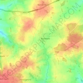
Mapa topográfico Blackmore, Hook End and Wyatts Green
Mapa interactivo
Haga clic en el mapa para ver la altitud.
Acerca de este mapa
Nombre: Mapa topográfico Blackmore, Hook End and Wyatts Green, altitud, relieve.
Altitud media: 81 m
Altitud mínima: 50 m
Altitud máxima: 107 m
Otros mapas topográficos
Haga clic en un mapa para ver su topografía, su altitud y su relieve.
Hutton
United Kingdom > England > Brentwood > Hutton
Hutton, Brentwood, Essex, East of England, England, CM13 1QR, United Kingdom
Altitud media: 66 m
Kelvedon Hatch
United Kingdom > England > Brentwood > Brentwood
Kelvedon Hatch, Brentwood, Essex, East of England, England, United Kingdom
Altitud media: 73 m
Brook Street
United Kingdom > England > Brentwood > Brook Street
Brook Street, Brentwood, Essex, East of England, England, CM14 4PG, United Kingdom
Altitud media: 75 m
Herongate and Ingrave
United Kingdom > England > Brentwood
Herongate and Ingrave, Brentwood, Essex, East of England, England, United Kingdom
Altitud media: 64 m