
Mapa topográfico Petrovaradin
Mapa interactivo
Haga clic en el mapa para ver la altitud.
Acerca de este mapa
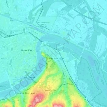
Nombre: Mapa topográfico Petrovaradin, altitud, relieve.
Altitud media: 90 m
Altitud mínima: 70 m
Altitud máxima: 212 m
Petrovaradin is located in the Syrmia region, on the Danube river and Fruška Gora, a horst mountain with elevation of 78–220 m (municipality up to 451 m). The northern part of Fruška Gora consists of massive landslide zones, but they are not active, except in Ribnjak neighborhood (between Sremska Kamenica and Petrovaradin fortress).