
Mapa topográfico Stormont, Dundas and Glengarry
Mapa interactivo
Haga clic en el mapa para ver la altitud.
Acerca de este mapa
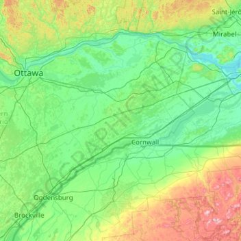
Nombre: Mapa topográfico Stormont, Dundas and Glengarry, altitud, relieve.
Altitud media: 153 m
Altitud mínima: 19 m
Altitud máxima: 974 m
Otros mapas topográficos
Haga clic en un mapa para ver su topografía, su altitud y su relieve.
Lac Saint-François
Canada > Ontario > Stormont, Dundas and Glengarry Counties > South Glengarry
Lac Saint-François, South Glengarry, Stormont, Dundas and Glengarry Counties, Est de l'Ontario, Ontario, J0P 1B0, Canada
Altitud media: 116 m