
Haz una donación
Equípate para tu próxima aventura:
Como asociado de Amazon, este sitio gana comisiones por las compras que califican, sin ningún costo adicional para usted.
Mapa topográfico Burao
Haga clic en el mapa para ver la altitud.
Haz una donación
Equípate para tu próxima aventura:
Como asociado de Amazon, este sitio gana comisiones por las compras que califican, sin ningún costo adicional para usted.
Burao
Weather in Burao, much like other inland towns in Somaliland, is very warm to hot and dry year-round. The city has a hot arid climate (Köppen BWh) in common with most of Somalia, although Burao's weather is moderated by altitude. The average daytime temperatures during the summer months of June and August can rise to 31 °C or 87.8 °F, with a low of 20 °C or 68 °F at night. The weather is cooler the rest of the year, averaging 27 °C or 80.6 °F during the day and 13 °C or 55.4 °F at nighttime. The city's limited rainfall of 222 millimetres or 9 inches usually comes with two peaks during April–May and October–November.
Haz una donación
Equípate para tu próxima aventura:
Como asociado de Amazon, este sitio gana comisiones por las compras que califican, sin ningún costo adicional para usted.
Acerca de este mapa
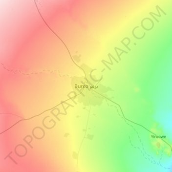
Nombre: Mapa topográfico Burao, altitud, relieve.
Lugar: Burao, Burao District, Togdheer, Somalia (9.36776 45.37811 9.68776 45.69811)
Altitud media: 1.051 m
Altitud mínima: 945 m
Altitud máxima: 1.171 m
Haz una donación
Equípate para tu próxima aventura:
Como asociado de Amazon, este sitio gana comisiones por las compras que califican, sin ningún costo adicional para usted.