
Mapa topográfico Rocca Calascio
Mapa interactivo
Haga clic en el mapa para ver la altitud.
Rocca Calascio
At an elevation of 1,512 metres (4,961 ft), the castle is the highest fortress in the Apennines. Built of stone and masonry exclusively for military purposes and intended only to accommodate troops and never as residence for nobles, the fortress overlooks the Plain of Navelli at one of the highest points in the ancient Barony of Carapelle.
Acerca de este mapa
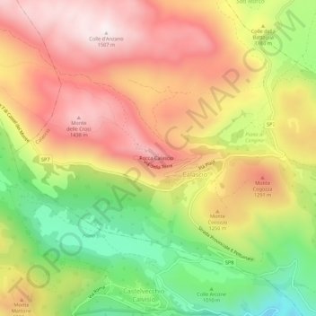
Nombre: Mapa topográfico Rocca Calascio, altitud, relieve.
Lugar: Rocca Calascio, Calascio, L'Aquila, Abruzzo, Italy (42.30803 13.67077 42.34803 13.71077)
Altitud media: 1.171 m
Altitud mínima: 777 m
Altitud máxima: 1.506 m