
Mapa topográfico Much Hadham
Mapa interactivo
Haga clic en el mapa para ver la altitud.
Acerca de este mapa
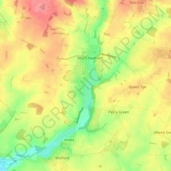
Nombre: Mapa topográfico Much Hadham, altitud, relieve.
Altitud media: 80 m
Altitud mínima: 37 m
Altitud máxima: 116 m
Otros mapas topográficos
Haga clic en un mapa para ver su topografía, su altitud y su relieve.
Pelham Gate
United Kingdom > England > Hertfordshire > East Hertfordshire
Pelham Gate, Brent Pelham, East Hertfordshire, Hertfordshire, England, SG9 0HL, United Kingdom
Altitud media: 113 m
Bishops Stortford Elsan Point
United Kingdom > England > Hertfordshire > East Hertfordshire
Bishops Stortford Elsan Point, East Hertfordshire, Hertfordshire, East of England, England, CM23 3BL, United Kingdom
Altitud media: 78 m
Buntingford
United Kingdom > England > Hertfordshire > East Hertfordshire
Buntingford, East Hertfordshire, Hertfordshire, England, United Kingdom
Altitud media: 110 m
Thorley
United Kingdom > England > Hertfordshire > East Hertfordshire > Thorley
Thorley, East Hertfordshire, Hertfordshire, East of England, England, United Kingdom
Altitud media: 82 m