
Haz una donación
Equípate para tu próxima aventura:
Como asociado de Amazon, este sitio gana comisiones por las compras que califican, sin ningún costo adicional para usted.
Mapa topográfico Darwen
Haga clic en el mapa para ver la altitud.
Haz una donación
Equípate para tu próxima aventura:
Como asociado de Amazon, este sitio gana comisiones por las compras que califican, sin ningún costo adicional para usted.
Darwen
The tower, which is open to the public, overlooks the town from the moors and stands at an altitude of 1,227 ft (374m) and has a height of 85 ft (26m). A spiral staircase leads to the top from where, on a clear day, Blackpool Tower, the Isle of Man, North Wales and the Furness Peninsula can be seen. In November 2010 the dome of the tower was blown off by strong winds. The dome was restored in January 2012.[27]
Haz una donación
Equípate para tu próxima aventura:
Como asociado de Amazon, este sitio gana comisiones por las compras que califican, sin ningún costo adicional para usted.
Acerca de este mapa
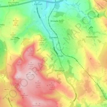
Nombre: Mapa topográfico Darwen, altitud, relieve.
Altitud media: 259 m
Altitud mínima: 123 m
Altitud máxima: 402 m
Haz una donación
Equípate para tu próxima aventura:
Como asociado de Amazon, este sitio gana comisiones por las compras que califican, sin ningún costo adicional para usted.
Otros mapas topográficos
Haga clic en un mapa para ver su topografía, su altitud y su relieve.
Winter Hill
United Kingdom > England > Blackburn with Darwen > Belmont
Paths to the summit lead from Belmont (in Blackburn with Darwen), Rivington (in Chorley), and Horwich and Blackrod (in Bolton). The summit can also be reached via a short walk from the top of a road pass 1+1⁄4 miles (2 km) west of Belmont. The hill is a prominent natural landmark on the skyline for the most…
Altitud media: 357 m
Haz una donación
Equípate para tu próxima aventura:
Como asociado de Amazon, este sitio gana comisiones por las compras que califican, sin ningún costo adicional para usted.
Haz una donación
Equípate para tu próxima aventura:
Como asociado de Amazon, este sitio gana comisiones por las compras que califican, sin ningún costo adicional para usted.
Winter Hill
United Kingdom > England > Blackburn with Darwen > Tockholes
Paths to the summit lead from Belmont (in Blackburn with Darwen), Rivington (in Chorley borough), and Horwich and Blackrod (in Bolton borough). The summit can also be reached via a short walk from the top of a road pass 1+1⁄4 miles (2 km) west of Belmont. The hill is a prominent feature on the skyline for…
Altitud media: 205 m
Higher Springfield
United Kingdom > England > Blackburn with Darwen > Guide > Higher Springfield
Altitud media: 202 m
Oakdale
United Kingdom > England > Blackburn with Darwen > Lower Darwen > Oakdale
Altitud media: 163 m
Haz una donación
Equípate para tu próxima aventura:
Como asociado de Amazon, este sitio gana comisiones por las compras que califican, sin ningún costo adicional para usted.
Winter Hill
United Kingdom > England > Blackburn with Darwen > Belmont
Paths to the summit lead from Belmont (in Blackburn with Darwen), Rivington (in Chorley), and Horwich and Blackrod (in Bolton). The summit can also be reached via a short walk from the top of a road pass 1+1⁄4 miles (2 km) west of Belmont. The hill is a prominent natural landmark on the skyline for the most…
Altitud media: 357 m
Haz una donación
Equípate para tu próxima aventura:
Como asociado de Amazon, este sitio gana comisiones por las compras que califican, sin ningún costo adicional para usted.
Winter Hill
United Kingdom > England > Blackburn with Darwen > Tockholes
Paths to the summit lead from Belmont (in Blackburn with Darwen), Rivington (in Chorley), and Horwich and Blackrod (in Bolton). The summit can also be reached via a short walk from the top of a road pass 1+1⁄4 miles (2 km) west of Belmont. The hill is a prominent natural landmark on the skyline for the most…
Altitud media: 205 m
Haz una donación
Equípate para tu próxima aventura:
Como asociado de Amazon, este sitio gana comisiones por las compras que califican, sin ningún costo adicional para usted.