
Mapa topográfico High Littleton
Haga clic en el mapa para ver la altitud.
Acerca de este mapa
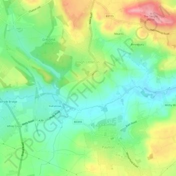
Nombre: Mapa topográfico High Littleton, altitud, relieve.
Altitud media: 122 m
Altitud mínima: 74 m
Altitud máxima: 201 m
Otros mapas topográficos
Haga clic en un mapa para ver su topografía, su altitud y su relieve.
Bathwick Hill
United Kingdom > England > Bath and North East Somerset > Bath
Number 1 (Bathwick Lodge) is a 2-storey villa with a steep Mansard room, built in 1825, extended in 1840 and the late C19. Probably by John Pinch the Elder.[4] Number 2 is from the early 19th century and has shutters over the windows.[11] Number 3 includes a porch which is elaborately enriched with carving,…
Altitud media: 93 m
Hallatrow
United Kingdom > England > Bath and North East Somerset > High Littleton
Altitud media: 119 m
Norton Hawkfield
United Kingdom > England > Bath and North East Somerset > Norton Malreward
Altitud media: 96 m
Little Solsbury Hill
United Kingdom > England > Bath and North East Somerset > Batheaston
Altitud media: 88 m
Park Corner
United Kingdom > England > Bath and North East Somerset > Freshford > Park Corner
Altitud media: 93 m
Chewton Keynsham
United Kingdom > England > Bath and North East Somerset > Compton Dando
Altitud media: 57 m
Carlingcott
United Kingdom > England > Bath and North East Somerset > Peasedown St. John
Altitud media: 123 m
Pipehouse
United Kingdom > England > Bath and North East Somerset > Hinton Charterhouse
Altitud media: 94 m
Keynsham Memorial Park
United Kingdom > England > Bath and North East Somerset > Keynsham
Altitud media: 29 m
Stoney Littleton
United Kingdom > England > Bath and North East Somerset > Shoscombe
Altitud media: 116 m
Clutton Hill
United Kingdom > England > Bath and North East Somerset > Farmborough
Altitud media: 133 m
Maes Knoll
United Kingdom > England > Bath and North East Somerset > Norton Malreward
Altitud media: 110 m
Wick Green
United Kingdom > England > Bath and North East Somerset > Bishop Sutton
Altitud media: 82 m