
Mapa topográfico Codsall
Haga clic en el mapa para ver la altitud.
Acerca de este mapa
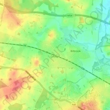
Nombre: Mapa topográfico Codsall, altitud, relieve.
Altitud media: 124 m
Altitud mínima: 96 m
Altitud máxima: 160 m
Otros mapas topográficos
Haga clic en un mapa para ver su topografía, su altitud y su relieve.
Weston Park
United Kingdom > England > Staffordshire > South Staffordshire > Weston under Lizard
Altitud media: 113 m
Levedale
United Kingdom > England > Staffordshire > South Staffordshire > Penkridge
Altitud media: 98 m
Calf Heath
United Kingdom > England > Staffordshire > South Staffordshire > Hatherton Junction
Altitud media: 113 m
Mottey Meadows NNR
United Kingdom > England > Staffordshire > South Staffordshire > Wheaton Aston
Altitud media: 110 m
Whiston
United Kingdom > England > Staffordshire > South Staffordshire > Penkridge
Altitud media: 95 m
Six Ashes
United Kingdom > England > Staffordshire > South Staffordshire > Bobbington
Altitud media: 125 m
Weston under Lizard
United Kingdom > England > Staffordshire > South Staffordshire
Altitud media: 111 m
Baggeridge Country Park
United Kingdom > England > Staffordshire > South Staffordshire
Altitud media: 146 m
Kinver Edge
United Kingdom > England > Staffordshire > South Staffordshire > Kinver
Altitud media: 95 m
Hatherton Junction
United Kingdom > England > Staffordshire > South Staffordshire
Altitud media: 112 m
Cannock Lake
United Kingdom > England > Staffordshire > South Staffordshire > Huntington
Altitud media: 149 m
Gospelash
United Kingdom > England > Staffordshire > South Staffordshire > Bobbington
Altitud media: 91 m
Kinver Edge
United Kingdom > England > Staffordshire > South Staffordshire > Kinver
Altitud media: 95 m