
Mapa topográfico Plettenberg
Mapa interactivo
Haga clic en el mapa para ver la altitud.
Acerca de este mapa
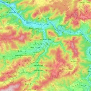
Nombre: Mapa topográfico Plettenberg, altitud, relieve.
Altitud media: 378 m
Altitud mínima: 186 m
Altitud máxima: 630 m
Plettenberg is located to the west of the Sauerland hills. The highest elevation of the town area is in the Ebbegebirge with 663 m above sea level, the lowest elevation with 194 m near Teindeln. The town is spread out between the four valleys of the rivers Lenne, Else, Oester [de] and Grüne.