
Mapa topográfico Markham
Mapa interactivo
Haga clic en el mapa para ver la altitud.
Acerca de este mapa
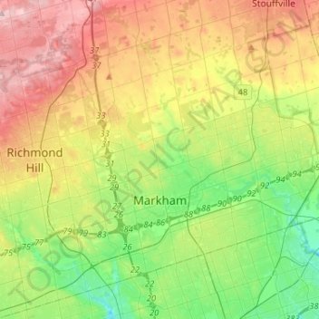
Nombre: Mapa topográfico Markham, altitud, relieve.
Lugar: Markham, York Region, Golden Horseshoe, Ontario, Canada (43.79804 -79.42873 43.96251 -79.17021)
Altitud media: 216 m
Altitud mínima: 135 m
Altitud máxima: 333 m
Markham's average altitude is at 200 m (660 ft) and in general consists of gently rolling hills. The city is intersected by two rivers; the Don River and Rouge River, as well as their tributaries. To the north is the Oak Ridges Moraine, which further elevates the elevation towards the north.
Otros mapas topográficos
Haga clic en un mapa para ver su topografía, su altitud y su relieve.
Whitchurch-Stouffville
Canada > Ontario > York Region
Whitchurch-Stouffville, York Region, Golden Horseshoe, Ontario, Canada
Altitud media: 295 m
Sutton
Canada > Ontario > York Region > Sutton
Sutton, Georgina, York Region, Golden Horseshoe, Ontario, L0E 1L0, Canada
Altitud media: 229 m