
Haz una donación
Equípate para tu próxima aventura:
Como asociado de Amazon, este sitio gana comisiones por las compras que califican, sin ningún costo adicional para usted.
Mapa topográfico Battle Ground
Haga clic en el mapa para ver la altitud.
Haz una donación
Equípate para tu próxima aventura:
Como asociado de Amazon, este sitio gana comisiones por las compras que califican, sin ningún costo adicional para usted.
Acerca de este mapa
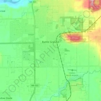
Nombre: Mapa topográfico Battle Ground, altitud, relieve.
Altitud media: 96 m
Altitud mínima: 30 m
Altitud máxima: 229 m
Haz una donación
Equípate para tu próxima aventura:
Como asociado de Amazon, este sitio gana comisiones por las compras que califican, sin ningún costo adicional para usted.
Otros mapas topográficos
Haga clic en un mapa para ver su topografía, su altitud y su relieve.
Lake River
United States > Washington > Clark County > Ridgefield
Lake River, a "slow, flat slough of the Columbia River", loses only 1 foot (30 cm) in elevation over its entire 11-mile (18 km) course. It flows north, roughly parallel to the Columbia until curving slightly northwest to join it. At times, tidal fluctuations and high flows along the Columbia cause Lake River…
Altitud media: 35 m
Haz una donación
Equípate para tu próxima aventura:
Como asociado de Amazon, este sitio gana comisiones por las compras que califican, sin ningún costo adicional para usted.
Haz una donación
Equípate para tu próxima aventura:
Como asociado de Amazon, este sitio gana comisiones por las compras que califican, sin ningún costo adicional para usted.