
Haz una donación
Equípate para tu próxima aventura:
Como asociado de Amazon, este sitio gana comisiones por las compras que califican, sin ningún costo adicional para usted.
Mapa topográfico Gundagai
Haga clic en el mapa para ver la altitud.
Haz una donación
Equípate para tu próxima aventura:
Como asociado de Amazon, este sitio gana comisiones por las compras que califican, sin ningún costo adicional para usted.
Gundagai
Gundagai is an inland town with an elevation of 232 metres (761 ft). Almost all of the shire is located in the South West Slopes bio-region and is part of the Riverina agricultural region. The eastern part of the shire is considered part of the South Eastern Highlands bioregion.
Haz una donación
Equípate para tu próxima aventura:
Como asociado de Amazon, este sitio gana comisiones por las compras que califican, sin ningún costo adicional para usted.
Acerca de este mapa
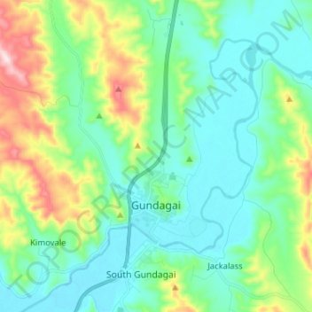
Nombre: Mapa topográfico Gundagai, altitud, relieve.
Altitud media: 309 m
Altitud mínima: 208 m
Altitud máxima: 622 m
Haz una donación
Equípate para tu próxima aventura:
Como asociado de Amazon, este sitio gana comisiones por las compras que califican, sin ningún costo adicional para usted.
Otros mapas topográficos
Haga clic en un mapa para ver su topografía, su altitud y su relieve.
Kangaroo Mount
Australia > New South Wales > Cootamundra-Gundagai Regional Council > Gobarralong
Altitud media: 255 m
Burrinjuck Dam
Australia > New South Wales > Cootamundra-Gundagai Regional Council > Wee Jasper > Adjungbilly
Altitud media: 548 m
The Three Sisters
Australia > New South Wales > Cootamundra-Gundagai Regional Council > Cootamundra
Altitud media: 403 m