
Mapa topográfico Herstal
Mapa interactivo
Haga clic en el mapa para ver la altitud.
Acerca de este mapa
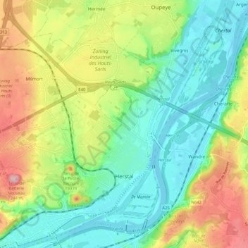
Nombre: Mapa topográfico Herstal, altitud, relieve.
Lugar: Herstal, Luik, Wallonië, 4040, België (50.65470 5.55531 50.70246 5.65705)
Altitud media: 113 m
Altitud mínima: 53 m
Altitud máxima: 219 m
De stad ligt in het laagterras van de Maas, op een hoogte van ongeveer 70 meter. Naar het westen toe neemt de hoogte toe tot 145 meter, en is men in Haspengouw. In het noorden wordt Herstal begrensd door de autoweg A3. De Spoorlijn 34 doorsnijdt Herstal.
Otros mapas topográficos
Haga clic en un mapa para ver su topografía, su altitud y su relieve.
Villers-Saint-Siméon
België > Luik > Luik > Villers-Saint-Siméon
Villers-Saint-Siméon, Luik, Wallonië, 4453, België
Altitud media: 152 m
Grâce-Hollogne
België > Luik > Luik > Grâce-Hollogne
Grâce-Hollogne, Luik, Wallonië, 4460, België
Altitud media: 143 m
Remouchamps
België > Luik > Luik > Aywaille
Remouchamps, Aywaille, Luik, Wallonië, 4920, België
Altitud media: 222 m
Embourg
België > Luik > Luik > Chaudfontaine
Embourg, Chaudfontaine, Luik, Wallonië, 4050, België
Altitud media: 139 m
Rotheux-Rimière
België > Luik > Luik > Rotheux-Rimière
Rotheux-Rimière, Neupré, Luik, Wallonië, 4120, België
Altitud media: 233 m