
Mapa topográfico Pershing County
Mapa interactivo
Haga clic en el mapa para ver la altitud.
Acerca de este mapa
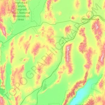
Nombre: Mapa topográfico Pershing County, altitud, relieve.
Lugar: Pershing County, Nevada, United States of America (39.99816 -119.33852 40.96106 -117.30002)
Altitud media: 1.449 m
Altitud mínima: 1.029 m
Altitud máxima: 2.962 m
According to the U.S. Census Bureau, the county has a total area of 6,067 square miles (15,710 km2), of which 6,037 square miles (15,640 km2) is land and 31 square miles (80 km2) (0.5%) is water. The tallest and most topographically prominent mountain in Pershing County is Star Peak at 9,840 ft (3,000 m).
Otros mapas topográficos
Haga clic en un mapa para ver su topografía, su altitud y su relieve.
Esmeralda County
United States of America > Nevada
Esmeralda County, Nevada, United States of America
Altitud media: 1.789 m
Washoe County
United States of America > Nevada
Washoe County, Nevada, United States of America
Altitud media: 1.528 m
Churchill County
United States of America > Nevada
Churchill County, Nevada, United States of America
Altitud media: 1.476 m
Elko County
United States of America > Nevada
Elko County, Nevada, United States of America
Altitud media: 1.838 m
White Pine County
United States of America > Nevada
White Pine County, Nevada, United States of America
Altitud media: 2.049 m