
Haz una donación
Equípate para tu próxima aventura:
Como asociado de Amazon, este sitio gana comisiones por las compras que califican, sin ningún costo adicional para usted.
Mapa topográfico Basin
Haga clic en el mapa para ver la altitud.
Haz una donación
Equípate para tu próxima aventura:
Como asociado de Amazon, este sitio gana comisiones por las compras que califican, sin ningún costo adicional para usted.
Acerca de este mapa
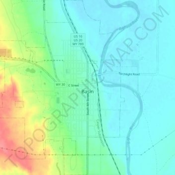
Nombre: Mapa topográfico Basin, altitud, relieve.
Lugar: Basin, Big Horn County, Wyoming, 82410, United States (44.36395 -108.06835 44.39745 -108.02908)
Altitud media: 1.188 m
Altitud mínima: 1.166 m
Altitud máxima: 1.244 m
Haz una donación
Equípate para tu próxima aventura:
Como asociado de Amazon, este sitio gana comisiones por las compras que califican, sin ningún costo adicional para usted.
Otros mapas topográficos
Haga clic en un mapa para ver su topografía, su altitud y su relieve.
Cloud Peak
United States > Wyoming > Big Horn County
Located in the 189,000-acre (765 km2) Cloud Peak Wilderness within Bighorn National Forest, the peak rises to an elevation of 13,171 feet (4,015 m). It can be climbed most easily from the western side, accessed by either the Battle Park or West Tensleep trailheads, which both form 24-mile (39 km) round trips…
Altitud media: 3.598 m
Cloud Peak
United States > Wyoming > Big Horn County
It rises to an elevation of 13,171 feet (4,015 m) and provides onlookers with dramatic views and vistas. The mountain can be climbed most easily from the western side, accessed by either the Battle Park or West Tensleep trail-heads and is roughly 24 miles round-trip from both. The peak is located in the…
Altitud media: 3.598 m
Haz una donación
Equípate para tu próxima aventura:
Como asociado de Amazon, este sitio gana comisiones por las compras que califican, sin ningún costo adicional para usted.