
Mapa topográfico Western Ghats
Mapa interactivo
Haga clic en el mapa para ver la altitud.
Acerca de este mapa
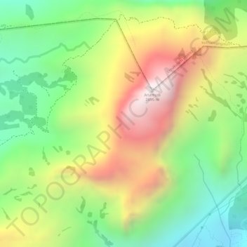
Nombre: Mapa topográfico Western Ghats, altitud, relieve.
Lugar: Western Ghats, Idukki, Kerala, 685614, India (10.16595 77.05795 10.16605 77.05805)
Altitud media: 2.225 m
Altitud mínima: 1.828 m
Altitud máxima: 2.685 m
The range starts near south of the Tapti river and runs approximately 1,600 km (990 mi) through the states of Gujarat, Maharashtra, Karnataka, Goa, Kerala and Tamil Nadu ending at Marunthuvazh Malai, Swamithope near the southern tip of India. These hills cover 160,000 km2 (62,000 sq mi) and form the catchment area for complex riverine drainage systems that drain almost 40% of India. The Western Ghats block the southwest monsoon winds from reaching the Deccan Plateau. The average elevation is around 1,200 m (3,900 ft).
Otros mapas topográficos
Haga clic en un mapa para ver su topografía, su altitud y su relieve.