
Mapa topográfico Millau
Mapa interactivo
Haga clic en el mapa para ver la altitud.
Acerca de este mapa
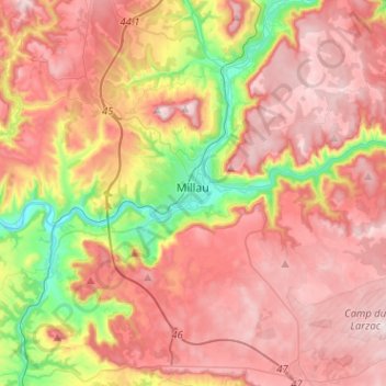
Nombre: Mapa topográfico Millau, altitud, relieve.
Lugar: Millau, Aveyron, Occitania, Metropolitan France, 12100, France (44.01667 2.99064 44.17985 3.24486)
Altitud media: 656 m
Altitud mínima: 331 m
Altitud máxima: 895 m
The territory of this town lies across a southern portion of the Massif Central. It covers a large area of some 16,823 hectares (41,570 acres), which makes it the 25th largest metropolitan town in France. The municipality lies at the heart of the Grands Causses, a part of the Causse Rouge (east of the plateau Lévézou), and part of Larzac as well as part of the Black Causse. The city county seat is located in the lower part of the town, in a large depression at the confluence of the Tarn and Dourbie, at an altitude of about 340 m.
Otros mapas topográficos
Haga clic en un mapa para ver su topografía, su altitud y su relieve.
Le Dourdou de Conques
Le Dourdou de Conques, Aveyron, Occitania, Metropolitan France, France
Altitud media: 576 m