
Haz una donación
Equípate para tu próxima aventura:
Como asociado de Amazon, este sitio gana comisiones por las compras que califican, sin ningún costo adicional para usted.
Mapa topográfico Northfield
Haga clic en el mapa para ver la altitud.
Haz una donación
Equípate para tu próxima aventura:
Como asociado de Amazon, este sitio gana comisiones por las compras que califican, sin ningún costo adicional para usted.
Acerca de este mapa
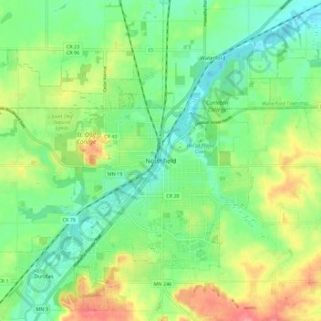
Nombre: Mapa topográfico Northfield, altitud, relieve.
Altitud media: 300 m
Altitud mínima: 269 m
Altitud máxima: 352 m
Haz una donación
Equípate para tu próxima aventura:
Como asociado de Amazon, este sitio gana comisiones por las compras que califican, sin ningún costo adicional para usted.
Otros mapas topográficos
Haga clic en un mapa para ver su topografía, su altitud y su relieve.
Northfield
United States > Minnesota > Rice County
According to the United States Census Bureau, the city has an area of 8.61 square miles (22.30 km2); 8.56 square miles (22.17 km2) is land and 0.05 square miles (0.13 km2) is water. The peak elevation is about 912 feet.
Altitud media: 298 m
Dundas
United States > Minnesota > Rice County
According to the United States Census Bureau, the city has a total area of 1.92 square miles (4.97 km2), all land. The Cannon River passes through the center of town. The latitude of Dundas is 44.429N. The longitude is 93.204W. Dundas' elevation is 932 feet above sea level.
Altitud media: 298 m
Haz una donación
Equípate para tu próxima aventura:
Como asociado de Amazon, este sitio gana comisiones por las compras que califican, sin ningún costo adicional para usted.
Northfield
United States > Minnesota > Rice County
According to the United States Census Bureau, the city has an area of 8.61 square miles (22.30 km2); 8.56 square miles (22.17 km2) is land and 0.05 square miles (0.13 km2) is water. The peak elevation is about 912 ft (278 m).
Altitud media: 298 m
Dundas
United States > Minnesota > Rice County
According to the United States Census Bureau, the city has a total area of 1.92 square miles (4.97 km2), all land. The Cannon River passes through the center of town. The latitude of Dundas is 44.429N. The longitude is 93.204W. Dundas' elevation is 932 feet above sea level.
Altitud media: 298 m
Northfield
United States > Minnesota > Rice County
According to the United States Census Bureau, the city has an area of 8.61 square miles (22.30 km2); 8.56 square miles (22.17 km2) is land and 0.05 square miles (0.13 km2) is water. The peak elevation is about 912 ft (278 m).
Altitud media: 298 m
Haz una donación
Equípate para tu próxima aventura:
Como asociado de Amazon, este sitio gana comisiones por las compras que califican, sin ningún costo adicional para usted.
Dundas
United States > Minnesota > Rice County
According to the United States Census Bureau, the city has a total area of 1.92 square miles (4.97 km2), all land. The Cannon River passes through the center of town. The latitude of Dundas is 44.429N. The longitude is 93.204W. Dundas' elevation is 932 feet above sea level.
Altitud media: 298 m
Haz una donación
Equípate para tu próxima aventura:
Como asociado de Amazon, este sitio gana comisiones por las compras que califican, sin ningún costo adicional para usted.