
Mapa topográfico Bryce Canyon National Park
Mapa interactivo
Haga clic en el mapa para ver la altitud.
Acerca de este mapa
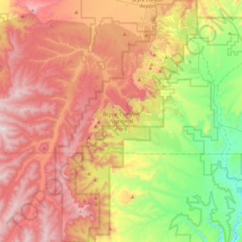
Nombre: Mapa topográfico Bryce Canyon National Park, altitud, relieve.
Altitud media: 2.259 m
Altitud mínima: 1.640 m
Altitud máxima: 2.902 m
Bryce Canyon National Park (/braɪs/) is an American national park located in southwestern Utah. The major feature of the park is Bryce Canyon, which despite its name, is not a canyon, but a collection of giant natural amphitheaters along the eastern side of the Paunsaugunt Plateau. Bryce is distinctive due to geological structures called hoodoos, formed by frost weathering and stream erosion of the river and lake bed sedimentary rocks. The red, orange, and white colors of the rocks provide spectacular views for park visitors. Bryce Canyon National Park is much smaller and sits at a much higher elevation than nearby Zion National Park. The rim at Bryce varies from 8,000 to 9,000 feet (2,400 to 2,700 m).
Otros mapas topográficos
Haga clic en un mapa para ver su topografía, su altitud y su relieve.
Hite Point
United States > Utah > Garfield County
Hite Point, Garfield County, Utah, United States
Altitud media: 1.348 m
Panguitch Lake
United States > Utah > Garfield County
Panguitch Lake, Garfield County, Utah, United States
Altitud media: 2.528 m
Cannonville
United States > Utah > Garfield County
Cannonville, Garfield County, Utah, 84718, United States
Altitud media: 1.894 m
Upper Calf Creek Fall
United States > Utah > Garfield County
Upper Calf Creek Fall, Garfield County, Utah, 84716, United States
Altitud media: 1.904 m
Piracy Point
United States > Utah > Garfield County
Piracy Point, Bryce Canyon Scenic Drive, Garfield County, Utah, United States
Altitud media: 2.551 m
Henderson Creek
United States > Utah > Garfield County
Henderson Creek, Garfield County, Utah, 84776, United States
Altitud media: 2.017 m
Antimony
United States > Utah > Garfield County
Antimony, Garfield County, Utah, 84712, United States
Altitud media: 2.061 m
Bryce Canyon
United States > Utah > Garfield County > Tropic
Bryce Canyon, Tropic, Garfield County, Utah, 84776, United States
Altitud media: 2.247 m
Escalante
United States > Utah > Garfield County
Escalante, Garfield County, Utah, 84726, United States
Altitud media: 1.781 m
Hatch
United States > Utah > Garfield County
Hatch, Garfield County, Utah, 84735, United States
Altitud media: 2.135 m
Bryce Canyon City
United States > Utah > Garfield County > Bryce Canyon City
Bryce Canyon City, Garfield County, Utah, 84764, United States
Altitud media: 2.337 m
Panguitch
United States > Utah > Garfield County > Panguitch
Panguitch, Garfield County, Utah, 87459, United States
Altitud media: 2.081 m
Andy Miller Flats
United States > Utah > Garfield County
Andy Miller Flats, Garfield County, Utah, United States
Altitud media: 1.604 m
Panguitch
United States > Utah > Garfield County
Panguitch, Garfield County, Utah, United States
Altitud media: 2.043 m
Capitol Reef National Park
United States > Utah > Garfield County
Capitol Reef National Park, Garfield County, Utah, United States
Altitud media: 1.963 m