
Haz una donación
Equípate para tu próxima aventura:
Como asociado de Amazon, este sitio gana comisiones por las compras que califican, sin ningún costo adicional para usted.
Mapa topográfico Big Bear City
Haga clic en el mapa para ver la altitud.
Haz una donación
Equípate para tu próxima aventura:
Como asociado de Amazon, este sitio gana comisiones por las compras que califican, sin ningún costo adicional para usted.
Big Bear City
It is estimated that the Serrano natives first settled in Big Bear between 1,500 and 2,000 years ago. The Serranos had both winter and summer settlements throughout the area. While their winter village was located in Lucerne Valley, they relocated to villages in the San Bernardino mountains during summer, as the altitude provided cooler temperatures. Villages were often located by rivers and lakes, however, mountain hunting camps were also established on higher elevations. Besides hunting, they also consumed pinyon nuts, mesquite beans, screw-beans, juniper berries and seeds. One of four major Serrano ethnographic sites was located in Big Bear City, called: Kayah-pia-t. Big Bear, and Lucerne Valley clans, both belonged to the same tribe: the Coyote Pervetum.
Haz una donación
Equípate para tu próxima aventura:
Como asociado de Amazon, este sitio gana comisiones por las compras que califican, sin ningún costo adicional para usted.
Acerca de este mapa
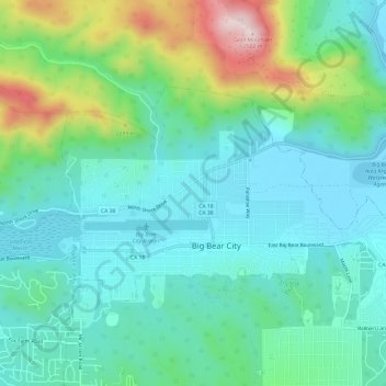
Nombre: Mapa topográfico Big Bear City, altitud, relieve.
Altitud media: 2.155 m
Altitud mínima: 2.042 m
Altitud máxima: 2.504 m
Haz una donación
Equípate para tu próxima aventura:
Como asociado de Amazon, este sitio gana comisiones por las compras que califican, sin ningún costo adicional para usted.
Otros mapas topográficos
Haga clic en un mapa para ver su topografía, su altitud y su relieve.
San Bernardino
United States > California > San Bernardino County
San Bernardino features a hot-summer Mediterranean climate (Csa in the Köppen climate classification) with mild winters and hot, dry summers. Relative to other areas in Southern California, winters are colder, with frost and with chilly to cold morning temperatures common. The particularly arid climate during…
Altitud media: 571 m
Fort Irwin
United States > California > San Bernardino County
Fort Irwin National Training Center (Fort Irwin NTC) is a major training area for the United States military in the Mojave Desert in northern San Bernardino County, California. Fort Irwin is at an average elevation of 2,454 feet (748 m). It is located 37 miles (60 km) northeast of Barstow, in the Calico…
Altitud media: 785 m
Haz una donación
Equípate para tu próxima aventura:
Como asociado de Amazon, este sitio gana comisiones por las compras que califican, sin ningún costo adicional para usted.
Haz una donación
Equípate para tu próxima aventura:
Como asociado de Amazon, este sitio gana comisiones por las compras que califican, sin ningún costo adicional para usted.
San Gorgonio Mountain
United States > California > San Bernardino County
Since it is the highest point in a region which is separated from higher peaks (e.g. in the Sierra Nevada) by relatively low terrain, San Gorgonio Mountain is one of the most topographically prominent peaks in the United States. It is ranked 7th among peaks in the 48 contiguous states and 18th overall.
Altitud media: 3.154 m
Haz una donación
Equípate para tu próxima aventura:
Como asociado de Amazon, este sitio gana comisiones por las compras que califican, sin ningún costo adicional para usted.
San Bernardino
United States > California > San Bernardino County > San Bernardino
Altitud media: 656 m
Upland
United States > California > San Bernardino County
Upland is a city in San Bernardino County, California, United States on the border with neighboring Los Angeles County. The municipality is located at an elevation of 1,242 feet (379 m). As of the 2020 census, the city had a population of 79,040, up from 73,732 at the 2010 census and 68,393 at the 2000 census.…
Altitud media: 457 m
Fontana
United States > California > San Bernardino County
Most of the city of Fontana, like its eastern neighbors Rialto and San Bernardino, is built atop a geologically young, gently southward-sloping alluvial fan from nearby Lytle Creek, deposited mainly during the Holocene and late-Pleistocene epochs. There are also sedimentary deposits of similar age from…
Altitud media: 414 m
Haz una donación
Equípate para tu próxima aventura:
Como asociado de Amazon, este sitio gana comisiones por las compras que califican, sin ningún costo adicional para usted.
Rialto
United States > California > San Bernardino County > Rialto
The particularly arid climate during the summer prevents tropospheric clouds from forming, meaning temperatures rise to what is considered Class Orange by NOAA. Rialto gets an average of 16 inches (410 mm) of rain, and maybe hail most of this rainfall precipitates in winter. During winter, Rialto's…
Altitud media: 387 m
Wrightwood
United States > California > San Bernardino County
Wrightwood is a census-designated place in San Bernardino County, California. It sits at an elevation of 6,000 feet (1,800 m). The population was 4,525 at the 2010 census, up from the population of 3,837 at the 2000 census. Wrightwood is located 77 miles (124 km) northeast of Los Angeles. Wrightwood is on the…
Altitud media: 1.952 m