
Mapa topográfico Lowell
Mapa interactivo
Haga clic en el mapa para ver la altitud.
Lowell
Lowell is located at the confluence of the Merrimack and Concord rivers. The Pawtucket Falls, a mile-long set of rapids with a total drop in elevation of 32 feet, ends where the two rivers meet. At the top of the falls is the Pawtucket Dam, designed to turn the upper Merrimack into a millpond, diverted through Lowell's extensive canal system.
Acerca de este mapa
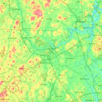
Nombre: Mapa topográfico Lowell, altitud, relieve.
Altitud media: 55 m
Altitud mínima: 2 m
Altitud máxima: 172 m