
Mapa topográfico Epperstone CP
Haga clic en el mapa para ver la altitud.
Epperstone CP
The report notes Epperstone's "very distinctive character... a combination of topography, buildings, trees and walls.... The constantly changing views make it an attractive space to move through." It also notes, "The approach to the village from the west is along a tunnel formed by overhanging trees, including ash, holly, maple, horse chestnut and yew. This creates a strong sense of arrival as you enter the village." The report criticises additions made to the former police training centre in Main Street.
Acerca de este mapa
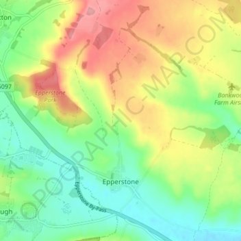
Nombre: Mapa topográfico Epperstone CP, altitud, relieve.
Altitud media: 69 m
Altitud mínima: 25 m
Altitud máxima: 129 m
Otros mapas topográficos
Haga clic en un mapa para ver su topografía, su altitud y su relieve.
Sherwood Forest NNR
United Kingdom > England > Nottinghamshire > Newark and Sherwood > Ollerton
Altitud media: 71 m
Blidworth Bottoms
United Kingdom > England > Nottinghamshire > Newark and Sherwood > Blidworth CP
Altitud media: 107 m
Goverton
United Kingdom > England > Nottinghamshire > Newark and Sherwood > Bleasby
Altitud media: 34 m
Vicar Water Country Park
United Kingdom > England > Nottinghamshire > Newark and Sherwood > Clipstone
Altitud media: 97 m
Spalford Warren
United Kingdom > England > Nottinghamshire > Newark and Sherwood > Spalford
Altitud media: 7 m
Farndon
United Kingdom > England > Nottinghamshire > Newark and Sherwood > Farndon
Altitud media: 14 m
Sherwood Forest NNR
United Kingdom > England > Nottinghamshire > Newark and Sherwood > Ollerton
Altitud media: 71 m