
Mapa topográfico Borsec
Mapa interactivo
Haga clic en el mapa para ver la altitud.
Acerca de este mapa
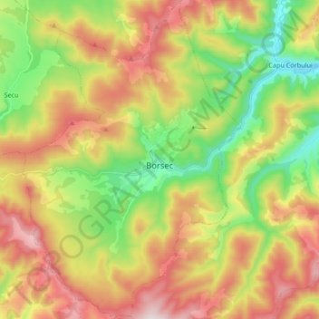
Nombre: Mapa topográfico Borsec, altitud, relieve.
Lugar: Borsec, Harghita, 535300, Romania (46.90908 25.48896 47.02268 25.60373)
Altitud media: 1.053 m
Altitud mínima: 712 m
Altitud máxima: 1.464 m
Borsec, a resort chiefly known for its mineral water and favourable climate, is situated in the intracarpatic depression of the same name, at an altitude of 900 m (3,000 ft). The Borsec Depression has an oval shape and is northeast oriented, being separated from the hilltop of the Rotunda Chair in two subunits. The locality is composed of two areas that correspond geographically to the two small depression areas that join: The Upper Borsec (Borsec de Sus) and The Lower Borsec (Borsec de Jos). The latter is southwest along national road DN15 [ro] at its junction with county road DJ128 Borsec-Ditrău, and Borsec de Sus (or the resort itself) is located on the plateau located northeast of the primary settlement, which is at higher altitude on average with 80–100 m. In the west, at a short distance, one can reach Toplița, the Pass of Creangă and to the east the Bistricioara valley. The Borsec depression is located at a higher altitude to that of Giurgeu but lower than that of Bilbor. Within the resort there are alleys and tourist trails, most of which are located in the outskirts of the resort, especially for visiting the nature monuments from the reservation of the Scaunul Rotund and Făget (Bükkhavas). They have the necessary arrangements to perform the field treatment under appropriate conditions, including tourist markings.
Otros mapas topográficos
Haga clic en un mapa para ver su topografía, su altitud y su relieve.
Carpathian Mountains
Carpathian Mountains, Toplița, Harghita, 535705, Romania
Altitud media: 980 m
Izvoru Mureșului
Izvoru Mureșului, Voșlăbeni, Harghita, 537356, Romania
Altitud media: 887 m
Miercurea Ciuc
Romania > Harghita > Miercurea Ciuc
Miercurea Ciuc, Harghita, Romania
Altitud media: 689 m