
Haz una donación
Equípate para tu próxima aventura:
Como asociado de Amazon, este sitio gana comisiones por las compras que califican, sin ningún costo adicional para usted.
Mapa topográfico Semmes
Haga clic en el mapa para ver la altitud.
Haz una donación
Equípate para tu próxima aventura:
Como asociado de Amazon, este sitio gana comisiones por las compras que califican, sin ningún costo adicional para usted.
Semmes
Semmes is located at 30.778N, -88.259W. Elevation is 256 feet. The Semmes area is bounded to the North by the Citronelle area, bounded to the East by the cities of Saraland and Prichard, bounded to the South by the city of Mobile, and finally bounded to the West by Big Creek Lake.
Haz una donación
Equípate para tu próxima aventura:
Como asociado de Amazon, este sitio gana comisiones por las compras que califican, sin ningún costo adicional para usted.
Acerca de este mapa
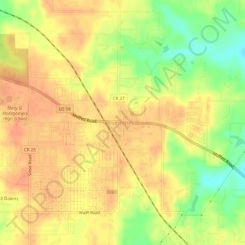
Nombre: Mapa topográfico Semmes, altitud, relieve.
Lugar: Semmes, Mobile County, Alabama, 36575, United States (30.75869 -88.27884 30.79869 -88.23884)
Altitud media: 68 m
Altitud mínima: 40 m
Altitud máxima: 82 m
Haz una donación
Equípate para tu próxima aventura:
Como asociado de Amazon, este sitio gana comisiones por las compras que califican, sin ningún costo adicional para usted.