
Mapa topográfico High Island Reservoir
Mapa interactivo
Haga clic en el mapa para ver la altitud.
Acerca de este mapa
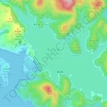
Nombre: Mapa topográfico High Island Reservoir, altitud, relieve.
Altitud media: 78 m
Altitud mínima: -1 m
Altitud máxima: 315 m
Otros mapas topográficos
Haga clic en un mapa para ver su topografía, su altitud y su relieve.
Sai Kung East Country Park
Sai Kung East Country Park, Sai Kung Sai Wan Road, Tai Long, Lan Nai Wan, Sai Kung District, Hong Kong, PRC
Altitud media: 62 m