
Mapa topográfico Dospat
Mapa interactivo
Haga clic en el mapa para ver la altitud.
Acerca de este mapa
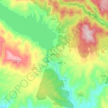
Nombre: Mapa topográfico Dospat, altitud, relieve.
Lugar: Dospat, Smolyan, 4831, Bulgaria (41.60836 24.11933 41.68836 24.19933)
Altitud media: 1.304 m
Altitud mínima: 1.058 m
Altitud máxima: 1.647 m
The town was probably founded by Despot Alexius Slav in the 12th or 13th century, from whose title (despot) its name is very likely derived. Dospat Dam is the highest dam in Bulgaria by altitude and, with its 22 km2 of water area, the second largest in capacity. It is fed by the River Dospat. At the bottom of the lake is a former German military airport from the Second World War.
Otros mapas topográficos
Haga clic en un mapa para ver su topografía, su altitud y su relieve.