
Mapa topográfico Narni
Mapa interactivo
Haga clic en el mapa para ver la altitud.
Acerca de este mapa
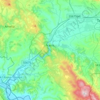
Nombre: Mapa topográfico Narni, altitud, relieve.
Lugar: Narni, Terni, Umbria, 05035, Italy (42.42158 12.41137 42.60082 12.61466)
Altitud media: 250 m
Altitud mínima: 42 m
Altitud máxima: 1.017 m
Narni (Latin: Narnia) is an ancient hilltown and comune of Umbria, in central Italy, with 19,252 inhabitants (2017). At an altitude of 240 metres (790 ft), it overhangs a narrow gorge of the Nera River in the province of Terni. It is very close to the geographic center of Italy. There is a stone on the exact spot with a sign in multiple languages.
Otros mapas topográficos
Haga clic en un mapa para ver su topografía, su altitud y su relieve.