
Haz una donación
Equípate para tu próxima aventura:
Como asociado de Amazon, este sitio gana comisiones por las compras que califican, sin ningún costo adicional para usted.
Mapa topográfico Saint Paul Island
Haga clic en el mapa para ver la altitud.
Haz una donación
Equípate para tu próxima aventura:
Como asociado de Amazon, este sitio gana comisiones por las compras que califican, sin ningún costo adicional para usted.
Saint Paul Island
Saint Paul is the largest of the Pribilof Islands and lies the farthest north. With a width of 7.66 mi (12.33 km) at its widest point and a length of 13.5 mi (21.7 km) on its longest axis (which runs from northeast to southwest), it has a total area of 43 sq mi (110 km2). Volcanic in origin, Saint Paul features a number of cinder cones and volcanic craters in its interior. The highest of these, Rush Hill, rises to 665 ft (203 m) on the island's western shore, though most of the upland areas average less than 150 ft (46 m) in elevation. Most of the island is a low-lying mix of rocky plateaus and valleys, with some of the valleys holding freshwater ponds. Much of its 45.5 mi (73.2 km) of shoreline is rugged and rocky, rising to sheer cliffs at several headlands, though long sandy beaches backed by shifting sand dunes flank a number of shallow bays.
Haz una donación
Equípate para tu próxima aventura:
Como asociado de Amazon, este sitio gana comisiones por las compras que califican, sin ningún costo adicional para usted.
Acerca de este mapa
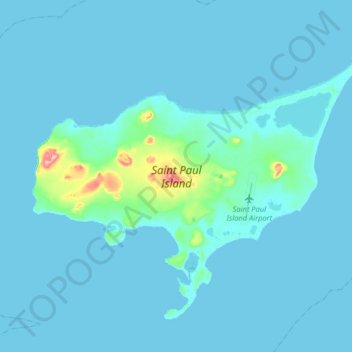
Nombre: Mapa topográfico Saint Paul Island, altitud, relieve.
Altitud media: 10 m
Altitud mínima: 0 m
Altitud máxima: 192 m
Haz una donación
Equípate para tu próxima aventura:
Como asociado de Amazon, este sitio gana comisiones por las compras que califican, sin ningún costo adicional para usted.
Otros mapas topográficos
Haga clic en un mapa para ver su topografía, su altitud y su relieve.