
Mapa topográfico Shag Harbour
Mapa interactivo
Haga clic en el mapa para ver la altitud.
Acerca de este mapa
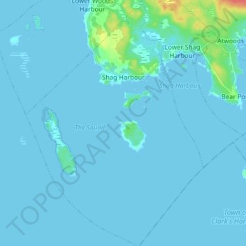
Nombre: Mapa topográfico Shag Harbour, altitud, relieve.
Altitud media: 3 m
Altitud mínima: -1 m
Altitud máxima: 45 m
Otros mapas topográficos
Haga clic en un mapa para ver su topografía, su altitud y su relieve.
East Sable River
Canada > Nova Scotia > Shelburne County
East Sable River, Municipality of the District of Shelburne, Shelburne County, Nova Scotia, B0T 1V0, Canada
Altitud media: 17 m
Clam Creek
Canada > Nova Scotia > Shelburne County > Cape Negro
Clam Creek, Cape Negro, Municipality of the District of Barrington, Shelburne County, Nova Scotia, B0W 1K0, Canada
Altitud media: 2 m
Shag Harbour Pond
Canada > Nova Scotia > Shelburne County > Lower Shag Harbour
Shag Harbour Pond, Lower Shag Harbour, Municipality of the District of Barrington, Shelburne County, Nova Scotia, B0W 3B0, Canada
Altitud media: 11 m
Sable River
Canada > Nova Scotia > Shelburne County
Sable River, Municipality of the District of Shelburne, Shelburne County, Nova Scotia, B0T 1J0, Canada
Altitud media: 50 m
Brook Islands
Canada > Nova Scotia > Shelburne County > Shag Harbour
Brook Islands, Shag Harbour, Municipality of the District of Barrington, Shelburne County, Nova Scotia, B0W 3B0, Canada
Altitud media: 9 m