
Mapa topográfico Odell
Mapa interactivo
Haga clic en el mapa para ver la altitud.
Acerca de este mapa
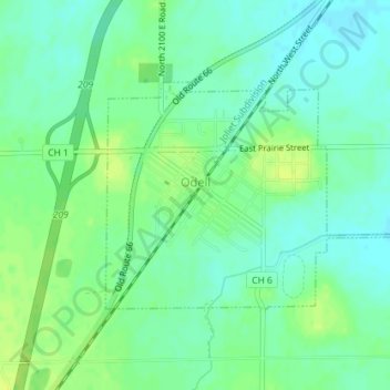
Nombre: Mapa topográfico Odell, altitud, relieve.
Lugar: Odell, Livingston County, Illinois, 60460, United States (40.99484 -88.53361 41.01056 -88.50151)
Altitud media: 218 m
Altitud mínima: 211 m
Altitud máxima: 226 m
Otros mapas topográficos
Haga clic en un mapa para ver su topografía, su altitud y su relieve.
Pontiac
United States > Illinois > Livingston County
Pontiac, Pontiac Township, Livingston County, Illinois, 61764, United States
Altitud media: 199 m
Long Point
United States > Illinois > Livingston County
Long Point, Livingston County, Illinois, United States
Altitud media: 195 m
Dwight
United States > Illinois > Livingston County
Dwight, Livingston County, Illinois, United States
Altitud media: 194 m
Cornell
United States > Illinois > Livingston County > Cornell
Cornell, Amity Township, Livingston County, Illinois, 61319, United States
Altitud media: 192 m
Cornell
United States > Illinois > Livingston County
Cornell, Amity Township, Livingston County, Illinois, United States
Altitud media: 193 m
Forrest
United States > Illinois > Livingston County
Forrest, Livingston County, Illinois, 61741, United States
Altitud media: 212 m