
Mapa topográfico Martinsville
Mapa interactivo
Haga clic en el mapa para ver la altitud.
Acerca de este mapa
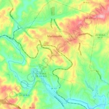
Nombre: Mapa topográfico Martinsville, altitud, relieve.
Lugar: Martinsville, Martinsville City, Virginia, United States (36.64381 -79.90408 36.71534 -79.82626)
Altitud media: 259 m
Altitud mínima: 194 m
Altitud máxima: 355 m
According to the United States Census Bureau, the city has a total area of 11.0 square miles (28.5 km2), of which 11.0 square miles (28.5 km2) is land and 0.1 square miles (0.3 km2) (0.5%) is water. The north side of the city has the highest average elevation. The east side slopes gradually down to the Smith River on the south side. The west side is hilly. Martinsville is located on the southern border of Southern Virginia.