
Mapa topográfico Prads-Haute-Bléone
Mapa interactivo
Haga clic en el mapa para ver la altitud.
Acerca de este mapa
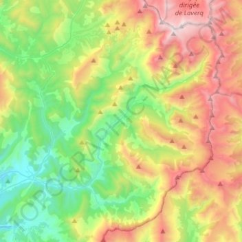
Nombre: Mapa topográfico Prads-Haute-Bléone, altitud, relieve.
Altitud media: 1.573 m
Altitud mínima: 749 m
Altitud máxima: 2.935 m
The municipality of Prads-Haute-Bléone extends over 16,500 hectares (41,000 acres), it is composed of nine hamlets ranging in elevation from 800 to 1 450 metres. The main settlement of Prads is at 1,048 metres (3,438 ft), and the highest peak is the Tête de l'Estrop at 2,961 metres (9,715 ft) in the Massif des Trois-Évêchés at the border with Méolans-Revel. This is also the highest summit of the Provence Alps and Prealps.