
Haz una donación
Equípate para tu próxima aventura:
Como asociado de Amazon, este sitio gana comisiones por las compras que califican, sin ningún costo adicional para usted.
Mapa topográfico Bot River
Haga clic en el mapa para ver la altitud.
Haz una donación
Equípate para tu próxima aventura:
Como asociado de Amazon, este sitio gana comisiones por las compras que califican, sin ningún costo adicional para usted.
Acerca de este mapa
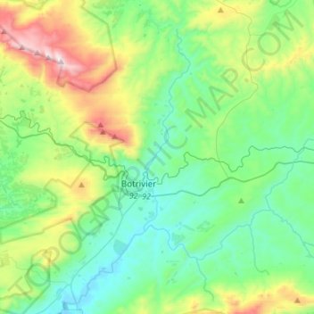
Nombre: Mapa topográfico Bot River, altitud, relieve.
Altitud media: 306 m
Altitud mínima: 0 m
Altitud máxima: 1.188 m
Haz una donación
Equípate para tu próxima aventura:
Como asociado de Amazon, este sitio gana comisiones por las compras que califican, sin ningún costo adicional para usted.
Otros mapas topográficos
Haga clic en un mapa para ver su topografía, su altitud y su relieve.
Riviersonderend
South Africa > Western Cape > Overberg District Municipality > Theewaterskloof Local Municipality
Altitud media: 212 m
Grabouw
South Africa > Western Cape > Overberg District Municipality > Theewaterskloof Local Municipality
The Elgin valley is South Africa's coolest climate wine-growing region and a range of other geographic factors (for example, its proximity to the Atlantic Ocean, cool temperatures, plentiful winter rainfall, prevailing wind directions, and altitude) have created a set of conditions for wine growing which are…
Altitud media: 358 m
Caledon
South Africa > Western Cape > Overberg District Municipality > Theewaterskloof Local Municipality
Altitud media: 311 m
Salt River
South Africa > Western Cape > Overberg District Municipality > Theewaterskloof Local Municipality
Altitud media: 240 m
Haz una donación
Equípate para tu próxima aventura:
Como asociado de Amazon, este sitio gana comisiones por las compras que califican, sin ningún costo adicional para usted.