
Mapa topográfico Hong Kong Park
Mapa interactivo
Haga clic en el mapa para ver la altitud.
Acerca de este mapa
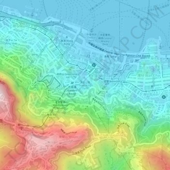
Nombre: Mapa topográfico Hong Kong Park, altitud, relieve.
Altitud media: 143 m
Altitud mínima: -3 m
Altitud máxima: 492 m
Otros mapas topográficos
Haga clic en un mapa para ver su topografía, su altitud y su relieve.
Pok Fu Lam Country Park
Pok Fu Lam Country Park, Lugard Road, Mid-levels, Hong Kong, Central and Western District, Hong Kong, CENTRAL, PRC
Altitud media: 185 m
Lung Fu Shan
Lung Fu Shan, Hong Kong, Central and Western District, Hong Kong, 1F, PRC
Altitud media: 136 m
Pak Tsz Lane Park
Pak Tsz Lane Park, Admiralty, Sheung Wan, Hong Kong, Central and Western District, Hong Kong, PRC
Altitud media: 113 m
Blake Garden
Blake Garden, Admiralty, Mid-levels, Hong Kong, Central and Western District, Hong Kong, PRC
Altitud media: 116 m
Tamar Park
Tamar Park, Admiralty, Central District, Hong Kong, Central and Western District, Hong Kong, PRC
Altitud media: 80 m
Cheung Kong Park
Cheung Kong Park, Cheung Kong Center, Central District, Hong Kong, Central and Western District, Hong Kong, PRC
Altitud media: 132 m
Mount Kellett
Mount Kellett, Hong Kong, Central and Western District, Hong Kong, RBL 561, PRC
Altitud media: 227 m