Geolocalizar

Mapa topográfico River Nidd

Haga clic en el mapa para ver la altitud.

👉 Easily get elevation data in JSON, GeoTIFF and KML formats using Elevation API
Gracias por apoyar a este sitio ❤️
Haz una donación

Equípate para tu próxima aventura:

Como asociado de Amazon, este sitio gana comisiones por las compras que califican, sin ningún costo adicional para usted.

Acerca de este mapa

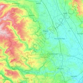
Nombre: Mapa topográfico River Nidd, altitud, relieve.

Lugar: River Nidd, North Yorkshire, York and North Yorkshire, England, United Kingdom (53.96563 -1.99758 54.18970 -1.21843)

Altitud media: 137 m

Altitud mínima: 4 m

Altitud máxima: 575 m

Otros mapas topográficos

Haga clic en un mapa para ver su topografía, su altitud y su relieve.

Greenhow Hill

United Kingdom > England > North Yorkshire

The village is about 3 miles (4.8 km) west of Pateley Bridge on the road heading towards Grassington, and is mainly in the civil parish of Bewerley. However, the western end of the village lying to the west of Kell Dyke, commonly known as Craven Cross, lies within the civil parish of Appletreewick in Craven.…

Altitud media: 358 m

Sessay

United Kingdom > England > North Yorkshire

Altitud media: 30 m

Reeth

United Kingdom > England > North Yorkshire

Altitud media: 295 m

Embsay

United Kingdom > England > North Yorkshire

Altitud media: 219 m

Lund

United Kingdom > England > North Yorkshire > Selby

Altitud media: 6 m

Nawton

United Kingdom > England > North Yorkshire

Altitud media: 78 m

Ilton

United Kingdom > England > North Yorkshire

Altitud media: 220 m

Thwaite

United Kingdom > England > North Yorkshire

Altitud media: 417 m

Low Row

United Kingdom > England > North Yorkshire

Altitud media: 358 m

Foxup

United Kingdom > England > North Yorkshire

Altitud media: 466 m

Harrogate

United Kingdom > England > North Yorkshire

Harrogate is situated on the edge of the Yorkshire Dales, with the Vale of York to the east and the upland Yorkshire Dales to the west and north-west. It has a dry and mild climate, typical of places in the rain shadow of the Pennines. It is on the A59 from Skipton to York. At an altitude of between 100 and…

Altitud media: 106 m

Farndale

United Kingdom > England > North Yorkshire > Ryedale > Gillamoor

With the population having decreased greatly from the 668 that is recorded in "A Topographical Dictionary of Yorkshire" by Thomas Lansdale published in 1822 when farndale East side had a population of 455 and Farndale West Side had a Population of 213.

Altitud media: 273 m

Clapham

United Kingdom > England > North Yorkshire > Craven

Altitud media: 203 m

Huby

United Kingdom > England > North Yorkshire

Altitud media: 92 m

Lockton

United Kingdom > England > North Yorkshire

Altitud media: 160 m

Aiskew

United Kingdom > England > North Yorkshire

Altitud media: 41 m

Equípate para tu próxima aventura:

🔥Iniciadores de Fuego - Asegura tu calor y cocina incluso en condiciones húmedas
🧦Calcetines de Lana Merino - Aislamiento premium para climas fríos
🔌Paneles solares portátiles - Carga sostenible en ruta
📦Organizadores de mochila - Orden del equipo en ruta
🛌Sacos de Dormir Térmicos - Máximo aislamiento con el mínimo peso y volumen

Como asociado de Amazon, este sitio gana comisiones por las compras que califican, sin ningún costo adicional para usted.