
Mapa topográfico Grayson County
Mapa interactivo
Haga clic en el mapa para ver la altitud.
Acerca de este mapa
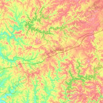
Nombre: Mapa topográfico Grayson County, altitud, relieve.
Lugar: Grayson County, Kentucky, USA (37.32081 -86.66849 37.62244 -86.01900)
Altitud media: 196 m
Altitud mínima: 121 m
Altitud máxima: 288 m
Otros mapas topográficos
Haga clic en un mapa para ver su topografía, su altitud y su relieve.
Little Georgetown
USA > Kentucky > Little Georgetown
Little Georgetown, Fayette County, Kentucky, 40513, USA
Altitud media: 285 m
Bowling Green
USA > Kentucky > Bowling Green
Bowling Green, Warren County, Kentucky, 42101, USA
Altitud media: 169 m
Mammoth Cave
USA > Kentucky > Mammoth Cave
Mammoth Cave, Edmonson County, Kentucky, USA
Altitud media: 214 m
Georgetown
USA > Kentucky > Georgetown
Georgetown, Scott County, Kentucky, 40324, USA
Altitud media: 265 m