
Mapa topográfico Saterland - Seelterlound
Mapa interactivo
Haga clic en el mapa para ver la altitud.
Acerca de este mapa
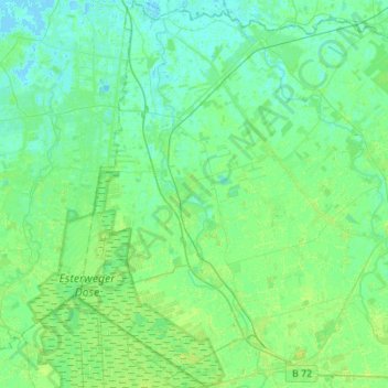
Nombre: Mapa topográfico Saterland - Seelterlound, altitud, relieve.
Altitud media: 5 m
Altitud mínima: -2 m
Altitud máxima: 14 m
Otros mapas topográficos
Haga clic en un mapa para ver su topografía, su altitud y su relieve.
Friesoythe
Germany > Lower Saxony > Cloppenburg district
Friesoythe, Cloppenburg district, Lower Saxony, 26169, Germany
Altitud media: 13 m
Saterland - Seelterlound
Germany > Lower Saxony > Cloppenburg district > Saterland - Seelterlound > Saterland - Seelterlound
Saterland - Seelterlound, Cloppenburg district, Lower Saxony, 26683, Germany
Altitud media: 6 m