
Mapa topográfico Ginsburg
Mapa interactivo
Haga clic en el mapa para ver la altitud.
Ginsburg
The town's largest flowing body of water is the Ferndorfbach, a tributary to the river Sieg. The municipal area's average elevation is 427 metres (1,401 ft) above sea level, with its highest elevation being at 678 metres (2,224 ft) at the Riemen, a peak in the Rothaargebirge.
Acerca de este mapa
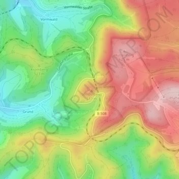
Nombre: Mapa topográfico Ginsburg, altitud, relieve.
Altitud media: 510 m
Altitud mínima: 381 m
Altitud máxima: 649 m