
Mapa topográfico Leh
Mapa interactivo
Haga clic en el mapa para ver la altitud.
Acerca de este mapa
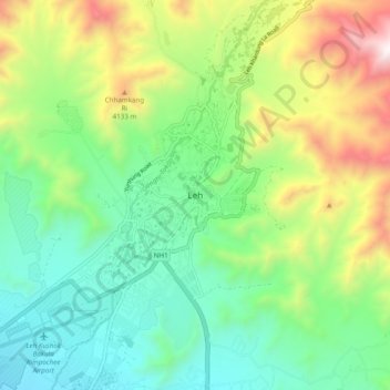
Nombre: Mapa topográfico Leh, altitud, relieve.
Lugar: Leh, Leh Tehsil, Leh district, Ladakh, India (34.12420 77.54481 34.20420 77.62481)
Altitud media: 3.653 m
Altitud mínima: 3.206 m
Altitud máxima: 4.572 m
Leh (/ˈlɛ/) (Ladakhi: གླེ) is the joint capital and largest city of Ladakh, a union territory of India. Leh, located in the Leh district, was also the historical capital of the Kingdom of Ladakh, the seat of which was in the Leh Palace, the former residence of the royal family of Ladakh, built in the same style and about the same time as the Potala Palace in Tibet. Leh is at an altitude of 3,524 m (11,562 ft), and is connected via National Highway 1 to Srinagar in the southwest and to Manali in the south via the Leh-Manali Highway (part of National Highway 3 connect leh).