
Haz una donación
Equípate para tu próxima aventura:
Como asociado de Amazon, este sitio gana comisiones por las compras que califican, sin ningún costo adicional para usted.
Mapa topográfico Mimbres
Haga clic en el mapa para ver la altitud.
Haz una donación
Equípate para tu próxima aventura:
Como asociado de Amazon, este sitio gana comisiones por las compras que califican, sin ningún costo adicional para usted.
Acerca de este mapa
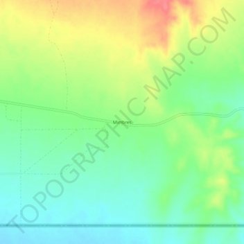
Nombre: Mapa topográfico Mimbres, altitud, relieve.
Lugar: Mimbres, Luna County, New Mexico, United States (31.78066 -107.77447 31.82066 -107.73447)
Altitud media: 1.327 m
Altitud mínima: 1.299 m
Altitud máxima: 1.369 m
Haz una donación
Equípate para tu próxima aventura:
Como asociado de Amazon, este sitio gana comisiones por las compras que califican, sin ningún costo adicional para usted.
Otros mapas topográficos
Haga clic en un mapa para ver su topografía, su altitud y su relieve.
Deming
United States > New Mexico > Luna County
Deming is located within the Upper Chihuahuan Desert climate zone. The climate is dry, hot, and breezy. Summer temperatures often exceed 100 °F (38 °C), but the altitude (4,300 feet (1,300 m)) and dry air sometimes make summer days more comfortable than one would expect given the high temperature.
Altitud media: 1.327 m