
Mapa topográfico Karimpur
Mapa interactivo
Haga clic en el mapa para ver la altitud.
Acerca de este mapa
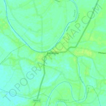
Nombre: Mapa topográfico Karimpur, altitud, relieve.
Lugar: Karimpur, Karimpur-I, Nadia, West Bengal, 741152, India (23.94160 88.58961 24.02160 88.66961)
Altitud media: 18 m
Altitud mínima: 13 m
Altitud máxima: 24 m
Karimpur is located at 23°58′N 88°37′E / 23.97°N 88.62°E / 23.97; 88.62. It has an average elevation of 15 metres (49 ft). It is 183 km (114 mi) from Kolkata and is located at the bank of the River Jalangi.