
Haz una donación
Equípate para tu próxima aventura:
Como asociado de Amazon, este sitio gana comisiones por las compras que califican, sin ningún costo adicional para usted.
Mapa topográfico Richfield
Haga clic en el mapa para ver la altitud.
Haz una donación
Equípate para tu próxima aventura:
Como asociado de Amazon, este sitio gana comisiones por las compras que califican, sin ningún costo adicional para usted.
Richfield
Richfield experiences a cold semi-arid climate (Köppen BSk) with four distinct seasons. Winter high temperatures average in the 30s and 40s with many milder days; low temperatures average in the teens and twenties, with a few mornings starting near or below zero. Snowfall is common, but usually melts in a day or two; however, deeper lasting snow cover is not uncommon. Still, December and January average among Richfield’s drier months. Summer days are warm, with normal July highs in the 90s and occasional hot spells that near 100 °F or 37.8 °C. Nighttime temperatures during the summer are comfortable—usually in the 50s or 60s. From July through September, “monsoonal” thunderstorms frequently form over the nearby peaks contributing to over a third of the 8.12 inches or 206.2 millimetres of annual rainfall. Because of its low humidity and mile-high altitude, the Sevier Valley experiences its average first frost by late September and its last in late May, despite the typically warm fall and spring days. Richfield’s record high is 104 °F (40 °C), set on July 23, 1931 and July 13-14, 1939, and the record low is −33 °F (−36.1 °C), set on February 6, 1989.
Haz una donación
Equípate para tu próxima aventura:
Como asociado de Amazon, este sitio gana comisiones por las compras que califican, sin ningún costo adicional para usted.
Acerca de este mapa
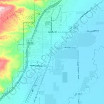
Nombre: Mapa topográfico Richfield, altitud, relieve.
Lugar: Richfield, Sevier County, Utah, United States (38.72436 -112.11753 38.79362 -112.06645)
Altitud media: 1.659 m
Altitud mínima: 1.599 m
Altitud máxima: 2.033 m
Haz una donación
Equípate para tu próxima aventura:
Como asociado de Amazon, este sitio gana comisiones por las compras que califican, sin ningún costo adicional para usted.
Otros mapas topográficos
Haga clic en un mapa para ver su topografía, su altitud y su relieve.