
Mapa topográfico Roberts Creek
Mapa interactivo
Haga clic en el mapa para ver la altitud.
Acerca de este mapa
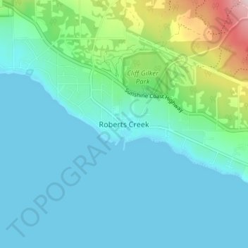
Nombre: Mapa topográfico Roberts Creek, altitud, relieve.
Altitud media: 56 m
Altitud mínima: -1 m
Altitud máxima: 317 m
Otros mapas topográficos
Haga clic en un mapa para ver su topografía, su altitud y su relieve.
Hind-Smith Lake
Canada > British Columbia > Sunshine Coast Regional District > Area D (Roberts Creek)
Hind-Smith Lake, Area D (Roberts Creek), Sunshine Coast Regional District, British Columbia, Canada
Altitud media: 1.186 m