
Haz una donación
Equípate para tu próxima aventura:
Como asociado de Amazon, este sitio gana comisiones por las compras que califican, sin ningún costo adicional para usted.
Mapa topográfico Chiloquin
Haga clic en el mapa para ver la altitud.
Haz una donación
Equípate para tu próxima aventura:
Como asociado de Amazon, este sitio gana comisiones por las compras que califican, sin ningún costo adicional para usted.
Chiloquin
Chiloquin is at an elevation of 4,180 feet (1,270 m) in Klamath County. The city is slightly east of U.S. Route 97 and slightly north of its intersection with Oregon Route 62. A short east–west highway, Oregon Route 422, links Route 97 at Chiloquin to Route 62 slightly south of Klamath Agency. By highway, Chiloquin is about 26 miles (42 km) north of Klamath Falls and 253 miles (407 km) south of Portland.
Haz una donación
Equípate para tu próxima aventura:
Como asociado de Amazon, este sitio gana comisiones por las compras que califican, sin ningún costo adicional para usted.
Acerca de este mapa
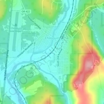
Nombre: Mapa topográfico Chiloquin, altitud, relieve.
Lugar: Chiloquin, Klamath County, Oregon, United States (42.56307 -121.88208 42.58478 -121.85693)
Altitud media: 1.302 m
Altitud mínima: 1.262 m
Altitud máxima: 1.395 m
Haz una donación
Equípate para tu próxima aventura:
Como asociado de Amazon, este sitio gana comisiones por las compras que califican, sin ningún costo adicional para usted.
Otros mapas topográficos
Haga clic en un mapa para ver su topografía, su altitud y su relieve.
Lake of the Woods
United States > Oregon > Klamath County
Lake of the Woods is located near the crest of the Cascade Mountains in western Klamath County, Oregon. Its elevation is 4,949 feet (1,508 m) above sea level. The lake is surrounded by the Fremont–Winema National Forest. Lake of the Woods is 33 miles (53 km) west of Klamath Falls and 43 miles (69 km) east of…
Altitud media: 1.588 m
Mount Mazama
United States > Oregon > Klamath County
Mount Mazama (Tum-sum-ne in the Native American language Klamath) is a complex volcano in the western U.S. state of Oregon, in a segment of the Cascade Volcanic Arc and Cascade Range. The volcano is in Klamath County, in the southern Cascades, 60 miles (97 km) north of the Oregon–California border. Its…
Altitud media: 1.880 m
Haz una donación
Equípate para tu próxima aventura:
Como asociado de Amazon, este sitio gana comisiones por las compras que califican, sin ningún costo adicional para usted.
Haz una donación
Equípate para tu próxima aventura:
Como asociado de Amazon, este sitio gana comisiones por las compras que califican, sin ningún costo adicional para usted.
Mount Scott
United States > Oregon > Klamath County
There is one trail to the summit of Mount Scott. Starting on Rim Drive, the trail is about 2.5 miles (4.0 km) long. It has many switchbacks, and ends at the fire lookout tower on the summit. The trailhead is at an elevation of 7,683 feet (2,342 m), and the trail climbs approximately 1,479 feet (451 m) to the…
Altitud media: 2.295 m
Haz una donación
Equípate para tu próxima aventura:
Como asociado de Amazon, este sitio gana comisiones por las compras que califican, sin ningún costo adicional para usted.