
Mapa topográfico Argentera
Mapa interactivo
Haga clic en el mapa para ver la altitud.
Acerca de este mapa
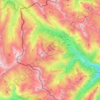
Nombre: Mapa topográfico Argentera, altitud, relieve.
Lugar: Argentera, Cuneo, Piedmont, Italy (44.31929 6.88701 44.42996 7.03051)
Altitud media: 2.195 m
Altitud mínima: 1.245 m
Altitud máxima: 2.935 m
Argentera borders the following municipalities: Acceglio, Canosio, Larche (France), Pietraporzio, and Saint-Etienne-de-Tinée (France). Its territory includes peaks such as the Oserot at an elevation of 2,860 metres (9,380 ft) above sea level, Enciastraia at 2,955 metres (9,695 ft) and the Rocca dei Tre Vescovi at 2,867 metres (9,406 ft).
Otros mapas topográficos
Haga clic en un mapa para ver su topografía, su altitud y su relieve.
Bersia
Italy > Piedmont > Cuneo > San Damiano Macra
Bersia, San Damiano Macra, Cuneo, Piedmont, 12020, Italy
Altitud media: 1.336 m
Fre
Italy > Piedmont > Cuneo > Montemale di Cuneo
Fre, Montemale di Cuneo, Cuneo, Piedmont, Italy
Altitud media: 997 m
Giardino Famiglia Allemandi
Italy > Piedmont > Cuneo > Villar San Costanzo > Pramallé
Giardino Famiglia Allemandi, Pramallé, Villar San Costanzo, Cuneo, Piedmont, Italy
Altitud media: 654 m
Punta Razil
Italy > Piedmont > Cuneo > Bagnolo Piemonte
Punta Razil, Bagnolo Piemonte, Cuneo, Piedmont, Italy
Altitud media: 2.008 m
Limone Piemonte
Limone Piemonte, Cuneo, Piedmont, 12015, Italy
Altitud media: 1.619 m